Application Description
For maritime enthusiasts and professionals alike, ShipAtlas by Maritime Optima is an indispensable vessel tracking application. Leveraging real-time AIS data from a network of over 700 satellites and terrestrial stations, ShipAtlas offers unparalleled insights into global shipping activities. Track vessels, analyze trade patterns, monitor port operations, explore sea routes, and access crucial information on marine weather, ice conditions, piracy risk areas, and detailed marine charts. The app continuously collects and processes raw AIS data from the global merchant fleet, ensuring high-quality, reliable information. Search capabilities extend to specific vessels (by name, IMO, or MMSI number), ports, and even vessel specifications (LOA, beam, draft, year built). Plan voyages with the integrated sea route calculator, providing estimated time of arrival, distance, time at sea, and projected fuel consumption. Manage custom vessel lists for effortless real-time monitoring, and stay informed with daily marine updates and customizable notifications. Enjoy a seamless user experience with cross-device data synchronization and dedicated customer support.
Key Features of ShipAtlas:
- Comprehensive Maritime Intelligence: Access detailed data on port activity, sea routes, weather, ice conditions, piracy zones, and nautical charts.
- Superior Data Quality: Rigorous data processing ensures accuracy and reliability of the AIS information.
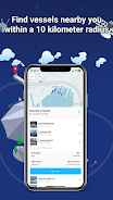
- Advanced Vessel Search: Locate vessels precisely using various criteria, including name, IMO/MMSI numbers, and vessel specifications.
- Sea Route Optimization: Quickly calculate estimated times of arrival, distances, transit times, and fuel consumption for planned routes.
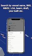
- Personalized Vessel Tracking: Create and manage unlimited vessel lists for continuous real-time monitoring on the integrated map.
Verdict:
ShipAtlas by Maritime Optima is a highly intuitive app delivering real-time AIS data and comprehensive maritime information. Its user-friendly design, combined with powerful features like the sea route calculator, makes it an invaluable asset for anyone involved in vessel tracking. While many features are freely accessible, a premium subscription unlocks enhanced capabilities. Download ShipAtlas today and embark on a journey of maritime exploration and data-driven decision-making. Learn more on our website.
Screenshot
Reviews
Post Comments
Latest Articles
Japan Gaming Stocks Dive on Trump Tariffs
Japanese video game companies experienced a significant stock market downturn following President Donald Trump's announcement of new tariffs.White House officials indicated targeted reciprocal tariffs on approximately 60 nations deemed "worst offende
It And Annabelle Writer-Producer Secures Screen Rights For The Medium: 'Anything Bloober Develops Is Going To Push Horror Forward In Unique And Terrifying Ways'
It and Annabelle writer-producer Gary Dauberman is preparing to bring Bloober Team’s The Medium to the big screen.As reported by Hollywood Reporter, Dauberman has secured the film rights to Bloober's intense horror title, though a director and scree

Sinners Hits $350M, Released Digitally
Director Ryan Coogler continues his winning streak. As Eric Goldman notes in his IGN review: "Having mastered boxing dramas and superhero films, Coogler now conquers horror with the vampire period piece Sinners. And unsurprisingly, he delivers anothe

Monument Valley 3 Documentary Reveals The Making Of
Ustwo Games has released a short documentary, "Building the Impossible: The Making of Monument Valley 3." The game arrived on PC and consoles last week, and this new video offers a deeper insight into the creative process behind the latest puzzle-adv
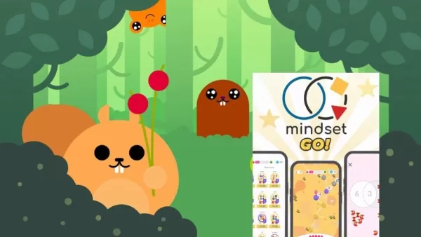
Mindset GO! Launches New Venn Diagram Puzzle Game
Mindset GO! elevates the smart-casual puzzle genre to a new level. Now available on Android, iOS, and the web, it merges keen observation with logical reasoning through a unique gameplay mechanic. Developed by Magicave, the game features a system rem
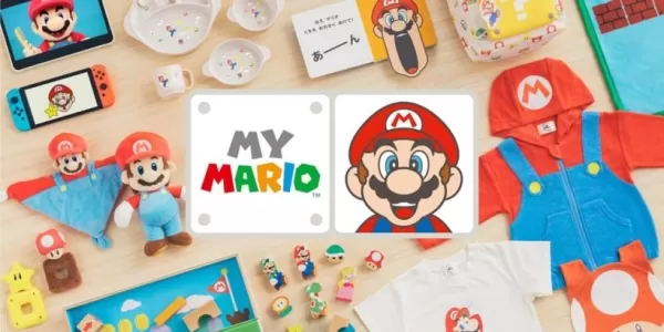
Hello, Mario! is a new made-for-kids app as part of Nintendo\'s big Mario push
Hello, Mario! is Nintendo’s latest venture into the Mario lifestyle experience.
It’s part of the new My Mario product line.
Gently poke, prod, or pinch Mario’s face—just like in the N64 version—to trigger a range of playful reactions. Those who grew
Apps like ShipAtlas by Maritime Optima

My Swisscom
Productivity丨357.00M

Tie Dye (Guide)
Productivity丨16.20M


ANDPAD
Productivity丨47.70M


Bakaláři OnLine
Productivity丨17.31M

Brilliant
Productivity丨13.50M

Easy Class
Productivity丨163.30M
Latest Apps

MotorSim 2
Auto & Vehicles丨4.5 MB

SMSBUS
Auto & Vehicles丨25.3 MB

Simply Auto
Auto & Vehicles丨17.0 MB
АльфаКар
Auto & Vehicles丨20.9 MB

Pion Smart Charger
Auto & Vehicles丨17.4 MB

Toronto Auto Brokers
Auto & Vehicles丨58.6 MB


Newmar
Auto & Vehicles丨67.6 MB

Дилижанс НН
Auto & Vehicles丨20.0 MB
Trending Apps
MORE +


Top News
MORE +

01
02-03
Roblox: Anime Adventures Codes (January 2025)
Anime Adventures Codes: A Comprehensive Guide to Free Gems and Rewards
This guide provides an up-to-date list of working and expired Anime Adventures codes in Roblox. Redeeming these codes grants valuable in-game gems and other rewards, giving you a head start in your adventure.
Updated January 5,
02
05-26
Enhance Your MU Immortal Experience with BlueStacks Features
MU Immortal captures the essence of classic MMORPG gameplay that fans adore—leveling up, enhancing stats, and crafting your ideal character. Designed primarily for mobile, the game truly shines when played on a PC using BlueStacks, thanks to an array of tools that streamline and enhance your gaming
03
05-16
"Clair Obscur: Expedition 33 Hits 1 Million Sales in 3 Days"
Clair Obscur: Expedition 33 has taken the gaming world by storm, achieving a phenomenal opening weekend by selling over 1 million copies just three days after its launch. This remarkable feat cements its status as the highest player-rated game of early 2025. Dive deeper into the journey of this grou
04
04-21
Roblox Anime Genesis: January 2025 Codes
Dive into the thrilling world of Anime Genesis, a dynamic tower defense game on Roblox where you assemble a squad of your favorite anime characters to fend off menacing monsters. Whether you're tackling levels solo or teaming up with friends, you'll earn gems that you can use to summon new heroes, e
05
01-20
New DLC and Preorder for FANTASIAN
FANTASIAN Neo Dimension: DLC and Pre-order Information
While anticipation for extra content is high, a FANTASIAN Neo Dimension DLC or story expansion is unlikely. Mistwalker head Hironobu Sakaguchi has stated his preference against sequels, aiming for complete, self-contained gaming experiences.
Topics
More +