Application Description
The PH Weather And Earthquakes app is your ultimate resource for staying updated on weather and seismic activities across the Philippines. Powered by data from PAGASA's Project NOAH and PHIVOLCS, this app delivers the latest weather forecasts, earthquake reports, tsunami warnings, and volcanic activity updates directly to your device. But the app doesn't stop there! It also features a global earthquake list sourced from U.S.G.S data, along with advanced monitoring tools such as Doppler radar, various sensors, and detailed hazard maps. Additionally, it offers a comprehensive directory of critical facilities and essential emergency tools like a flashlight and compass. With features including weekly and hourly weather forecasts, a moon phase calendar, and integration with PHIVOLCS Fault Finder and LAVA, the PH Weather And Earthquakes app is truly comprehensive. If you have suggestions for new features, simply visit their official Facebook page and leave a message. Stay informed and prepared with the PH Weather And Earthquakes app.
Features of PH Weather And Earthquakes:
Weather Updates: Receive real-time weather updates from PAGASA's Project NOAH, including detailed 4-hour and 4-day forecasts. Stay ahead of cyclones with timely updates on typhoons, hurricanes, and cyclones.
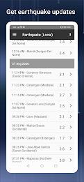
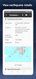
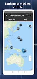
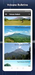
Earthquake, Tsunami, and Volcanic Activity Updates: Get instant notifications about earthquakes, tsunamis, and volcanic activities from PHIVOLCS. Stay safe and informed during natural disasters with timely alerts.
Monitoring Tools: Utilize a variety of monitoring tools such as Doppler radar, and sensors including stream gauge, rain gauge, tide level, and weather stations. Keep track of changing weather conditions in your area.
Hazard Maps: Access detailed hazard maps for floods, landslides, and storm surges. Easily identify high-risk areas to plan your travel or evacuation routes effectively.
Emergency Tools: Be ready for any emergency with crucial tools like a flashlight, strobe light, siren, and compass. Have a reliable set of tools at your fingertips to handle unexpected situations.
Additional Features: Explore further with MT Satellite images and videos, Ovitrap (dengue) reports, government Twitter updates, a list of critical facilities, and a moon phase calendar.
Conclusion:
Stay ahead of the curve with the PH Weather And Earthquakes app. Get real-time weather updates, earthquake alerts, and volcanic activity notifications. Use a range of monitoring tools and hazard maps to ensure your safety during natural disasters. Equip yourself with essential emergency tools and delve into additional features for a complete weather and disaster preparedness experience. Download the app today and stay one step ahead of unpredictable weather conditions and natural calamities.
Screenshot
Reviews
Post Comments
Latest Articles
It And Annabelle Writer-Producer Secures Screen Rights For The Medium: 'Anything Bloober Develops Is Going To Push Horror Forward In Unique And Terrifying Ways'
It and Annabelle writer-producer Gary Dauberman is preparing to bring Bloober Team’s The Medium to the big screen.As reported by Hollywood Reporter, Dauberman has secured the film rights to Bloober's intense horror title, though a director and scree

Sinners Hits $350M, Released Digitally
Director Ryan Coogler continues his winning streak. As Eric Goldman notes in his IGN review: "Having mastered boxing dramas and superhero films, Coogler now conquers horror with the vampire period piece Sinners. And unsurprisingly, he delivers anothe

Monument Valley 3 Documentary Reveals The Making Of
Ustwo Games has released a short documentary, "Building the Impossible: The Making of Monument Valley 3." The game arrived on PC and consoles last week, and this new video offers a deeper insight into the creative process behind the latest puzzle-adv

Mindset GO! Launches New Venn Diagram Puzzle Game
Mindset GO! elevates the smart-casual puzzle genre to a new level. Now available on Android, iOS, and the web, it merges keen observation with logical reasoning through a unique gameplay mechanic. Developed by Magicave, the game features a system rem
Hello, Mario! is a new made-for-kids app as part of Nintendo\'s big Mario push
Hello, Mario! is Nintendo’s latest venture into the Mario lifestyle experience.
It’s part of the new My Mario product line.
Gently poke, prod, or pinch Mario’s face—just like in the N64 version—to trigger a range of playful reactions. Those who grew

Splash Update Makes Waves in The Sims Freeplay
The Sims Freeplay introduces its latest lineup of in-game eventsHost a Pride Party, compete in a BBQ showdown, and rescue the community poolWatch for the arrival of the new neighborhood, Breezy FieldsWith summer in full swing (at least for those enjo
Apps like PH Weather And Earthquakes

ESMO Events
Lifestyle丨22.30M


Cheddar's Scratch Kitchen
Lifestyle丨203.60M


Aiuta – AI Stylist
Lifestyle丨24.78M


sonnenCharger App
Lifestyle丨60.80M

Latest Apps


OOhoo
Communication丨47.40M


Hottest
Communication丨26.00M

Mottu Motos
Auto & Vehicles丨72.7 MB


TVING
Video Players & Editors丨50.97M
Trending Apps
MORE +


Top News
MORE +

01
02-03
Roblox: Anime Adventures Codes (January 2025)
Anime Adventures Codes: A Comprehensive Guide to Free Gems and Rewards
This guide provides an up-to-date list of working and expired Anime Adventures codes in Roblox. Redeeming these codes grants valuable in-game gems and other rewards, giving you a head start in your adventure.
Updated January 5,
02
05-26
Enhance Your MU Immortal Experience with BlueStacks Features
MU Immortal captures the essence of classic MMORPG gameplay that fans adore—leveling up, enhancing stats, and crafting your ideal character. Designed primarily for mobile, the game truly shines when played on a PC using BlueStacks, thanks to an array of tools that streamline and enhance your gaming
03
05-16
"Clair Obscur: Expedition 33 Hits 1 Million Sales in 3 Days"
Clair Obscur: Expedition 33 has taken the gaming world by storm, achieving a phenomenal opening weekend by selling over 1 million copies just three days after its launch. This remarkable feat cements its status as the highest player-rated game of early 2025. Dive deeper into the journey of this grou
04
04-21
Roblox Anime Genesis: January 2025 Codes
Dive into the thrilling world of Anime Genesis, a dynamic tower defense game on Roblox where you assemble a squad of your favorite anime characters to fend off menacing monsters. Whether you're tackling levels solo or teaming up with friends, you'll earn gems that you can use to summon new heroes, e
05
01-20
New DLC and Preorder for FANTASIAN
FANTASIAN Neo Dimension: DLC and Pre-order Information
While anticipation for extra content is high, a FANTASIAN Neo Dimension DLC or story expansion is unlikely. Mistwalker head Hironobu Sakaguchi has stated his preference against sequels, aiming for complete, self-contained gaming experiences.
Topics
More +